In the world of drone-based surveying, precision is everything. Whether it’s for construction projects, agricultural planning, or environmental studies, surveyors rely on highly accurate data to make informed decisions. This is where aerial mapping GCPs (Ground Control Points) come into play. These strategically placed reference markers improve the accuracy of drone-captured images, ensuring that maps and 3D models reflect the real-world terrain with remarkable precision.
What Are Aerial Mapping GCPs?
Ground Control Points are clearly marked locations on the ground with known geographic coordinates. They act as anchor points that allow drone imagery to be correctly aligned to real-world positions during photogrammetric processing. By incorporating GCPs, survey teams can eliminate distortions and achieve centimeter-level accuracy in mapping results.
Key Characteristics of GCPs
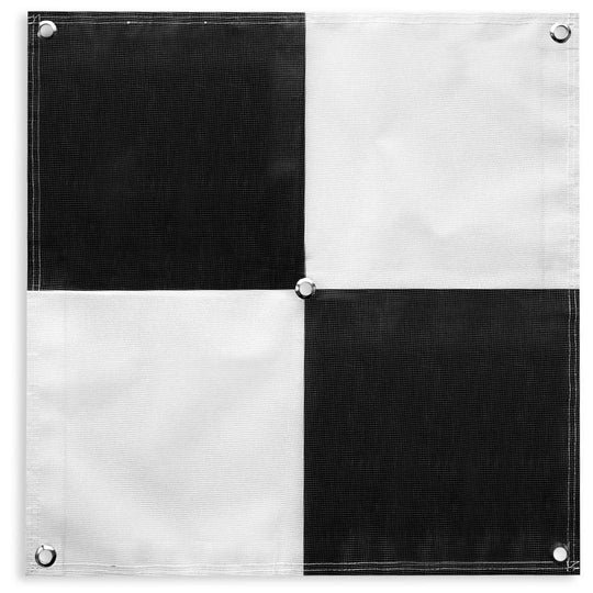
- Highly Visible Markers: Often designed in black and white patterns for camera recognition.
- Measured Coordinates: Each point’s exact position is determined using GPS equipment.
- Strategic Placement: Distributed across a survey area to maximize coverage and accuracy.
Why GCPs Are Critical in Drone Mapping
Modern drones are equipped with advanced GPS systems, but even these can sometimes produce slight inaccuracies due to satellite signal interference, altitude changes, or environmental conditions. GCPs bridge this gap by acting as reliable ground references, leading to more accurate maps and models.
Benefits of Using GCPs
- Enhanced Accuracy: Achieve precise georeferencing for high-quality mapping.
- Reduced Errors: Corrects positional errors from drone GPS.
- Improved Consistency: Ensures data remains uniform across large survey areas.
- Professional-Grade Results: Essential for industries like engineering, mining, and land surveying where centimeter-level precision is non-negotiable.
Applications of Aerial Mapping GCPs
The use of GCPs extends across multiple sectors where mapping accuracy is critical.
1. Construction and Infrastructure
Surveying large construction sites demands precise measurements to ensure accurate placement of structures. GCPs help in creating detailed topographical maps, monitoring site progress, and guiding earthmoving operations.
2. Agriculture
In precision farming, GCPs allow for the creation of accurate field maps that help farmers analyze soil health, optimize planting strategies, and monitor crop growth.
3. Environmental Studies
From monitoring erosion to tracking changes in forest cover, environmental researchers rely on drone data. GCPs ensure these images accurately reflect terrain conditions over time.
4. Mining Operations
Mining surveys require high-accuracy maps for volumetric measurements and excavation planning. GCPs provide the precision necessary for these high-stakes operations.
Best Practices for Placing GCPs
Proper placement of Ground Control Points is crucial for maximizing accuracy. Here are a few best practices:
Strategic Positioning
- Place GCPs evenly across the survey area, including corners and center points.
- Avoid placing markers near tall objects like trees or buildings to minimize shadow interference.
Marker Design
- Use high-contrast patterns (e.g., black-and-white crosses or checkerboards) for easy detection.
- Ensure markers are large enough to be visible in aerial imagery at the drone’s flight altitude.
Coordinate Measurement
- Use high-accuracy GPS or RTK (Real-Time Kinematic) systems to measure GCP coordinates.
- Double-check measurements to prevent alignment errors during processing.
Alternatives and Complementary Technologies
While GCPs remain a gold standard for aerial mapping, emerging technologies such as RTK drones and PPK (Post-Processing Kinematic) systems offer alternatives. These systems improve onboard GPS accuracy, sometimes reducing the need for numerous GCPs. However, for maximum reliability, combining these technologies with GCPs delivers the best results.
Challenges in Using GCPs
Despite their benefits, implementing GCPs comes with some challenges:
- Time-Consuming Setup: Placing and measuring GCPs can take hours, depending on the survey area.
- Additional Equipment Costs: High-precision GPS devices are required to measure GCPs accurately.
- Environmental Limitations: Rough terrains, dense vegetation, or water bodies may complicate marker placement.
Future of Drone Mapping Accuracy
The future of aerial mapping points to a combination of advanced drone GPS technology and traditional GCP methods. Innovations like AI-assisted ground referencing, automated GCP placement, and high-resolution onboard sensors may further reduce manual work while maintaining high accuracy standards.
Conclusion – Why GCPs Are Worth It
For professionals seeking top-tier accuracy in drone surveys, aerial mapping GCPs are essential. They provide the confidence that the data collected from drones reflects reality with minimal error. Whether used in construction, agriculture, mining, or environmental monitoring, GCPs continue to be a trusted method for achieving reliable mapping results.
Call to Action
Looking to improve the accuracy of your drone surveys? Invest in quality GCP markers and precise coordinate measurement tools to elevate your mapping projects. Start integrating aerial mapping GCPs today to unlock the full potential of drone-based surveying.
Related Reads
- Custom Fitness App Development: Build the Fitness App Your Users Actually Want
- Prison Connect Explained: How Our Service Helps Families Stay in Touch
- Hidden Secrets of Opal Gemstone No One Told You
- The Ultimate Holiday Statement: Decorating a 10 Feet Christmas Tree with Style
- Space Planning Tips: How to Fit a King Size Bed in Small or Medium Bedrooms
- Gate Physics Online Coaching: Unlock Your Success with Physics by Fiziks